<img height="1" width="1" style="display:none;" alt="" src="https://px.ads.linkedin.com/collect/?pid=3382404&amp;fmt=gif">
Skip to content


Photogrammetry
& Reality Mapping Capabilities

Drone, 360 Camera, & Smartphone Capabilities 

Reconstruct transforms all standard and 360 images or videos of your construction site into a 3D model that’s yours to measure, inspect, and explore.

Turn any job site footage into a 3D walkthrough.

Photogrammetry turns 2D images into precise, 3D maps of your building or structure. 
capture detailed construction site data using any device

CAPTURE WITH ANY DEVICE

upload captured construction site data into Reconstruct

FEED DATA TO RECONSTRUCT

Reconstruct transforms all data into a 3d digital twin

SEE YOUR PROJECT IN 3D

Reconstruct can...

Artboard 2_77

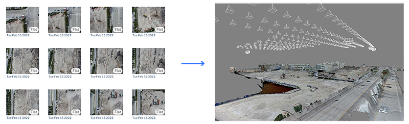
Make CameraS Smarter

Reconstruct determines your camera's position and orientation for each image or frame of footage, then solves for 3D points, maps, and surfaces for an even clearer picture.

Artboard 2_196

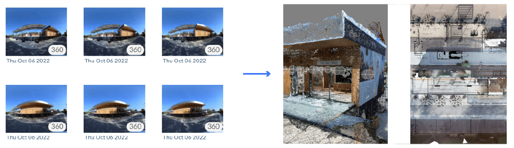
Connect Every Capture

Our engines piece together reality capture you've gathered on different types of hardware, day after day.


Artboard 2_52

Replicate Your Job Site

Reconstruct creates a precise, smooth, as-built digital twin of your job site that's yours to measure, inspect, and explore.


Artboard 88

Slash Job Site Travel

Reconstruct allows you to fluidly walk through your construction project without ever stepping foot on the job site.

Artboard 2_46

Incorporate New Footage

Our reality mapping technology matches and aligns new images to previously captured images, creating a 3D model that's always getting smarter.


Capture reality with virtually anything.

Just about any on-site employee can perform a reality capture walk.
360 camera

360 camera

Quick and Easy Mapping 

indoors


drone

drone

Large-Scale Mapping

outdoors


cell phone

Cell phone

For On-Demand Captures


matterport

Matterport

Photo-Realistic Walkthrough for Asset Management

indoors

laser scanning

laser scanning

High-Precision QA/QC Tasks

flatness test


Artboard 2-1

360 & Smartphone Capture

360 or standard photos or videos are automatically transformed into floor plans, orthophotos, 3D point clouds, and mesh models. The source footage is automatically organized against the reality map floor plan or models.

transformation of 360 and smartphone reality capture into 3d point cloud and floorplan
transformation of drone capture into 3d point cloud

Drone Capture

Drone images are automatically turned into a 3D point cloud. An orthophoto is also automatically overlaid on the jobsite map.

Meet the companies that trust Reconstruct.

John Jurewicz

John Jurewicz

General Manager

"Our initial value gain in using Reconstruct was making it more efficient to track work put in place, with the ability to gain direct insight into the cause of delay. We then also saw value in claim dispute and resolution. The integrations with lookahead planning improve communication between trades and show more transparently progress for leaders."

BurcinWeb-optimized

Burcin Kaplanoglu

Executive Director, Innovation Officer at Oracle Construction and Engineering

"The integration with Reconstruct has complemented Oracle’s platform by providing innovative and advanced progress reporting and risk management for construction projects. Since joining Oracle’s global startup program, Reconstruct has delivered significant value to our joint customers and we look forward to a long-term partnership."

Robert Trapp

Robert Trapp

BIM / VDC Manager

"Reconstruct has come up with a product that gives you a ring-side seat to the construction site even if you are miles away, letting you see progress and manage potential risk to the project."

Damon Ranieri

Damon Ranieri

Director of Virtual Design & Construction

"Leopardo uses Reconstruct as a compelling way to engage with our clients. In just the first few months of using it, we saw measurable improvements."

Zane Ardis

Zane Ardis

Project Manager

"Reconstruct helped keep us on schedule by identifying potential schedule task delays before they impact the overall schedule."

Ready to start reality mapping?